
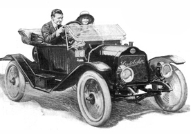
It’s a beautiful day and you’ve decided to take a jaunt in your newfangled automobile, going north along the scenic Hudson River. You can’t count on good, well-marked roads, so you’ve brought along the GPS system of the day—a copy of Photo-auto maps . . . New York to Albany which features “photographs of every turn . . . showing railroad crossings, bridges, school houses and all landmarks.”1
Thus equipped, you drive north on the historic Albany Post Road. You pass through Ossining and soon come to the next landmark, a fork in the road with a brick schoolhouse on the left. You hang a left at the fork, following the road downhill, and you see a huge chimney towering over an industrial building on the right. You wonder what it is but you can’t stop to look because a narrow iron bridge looms ahead, crossing the wide Croton River.
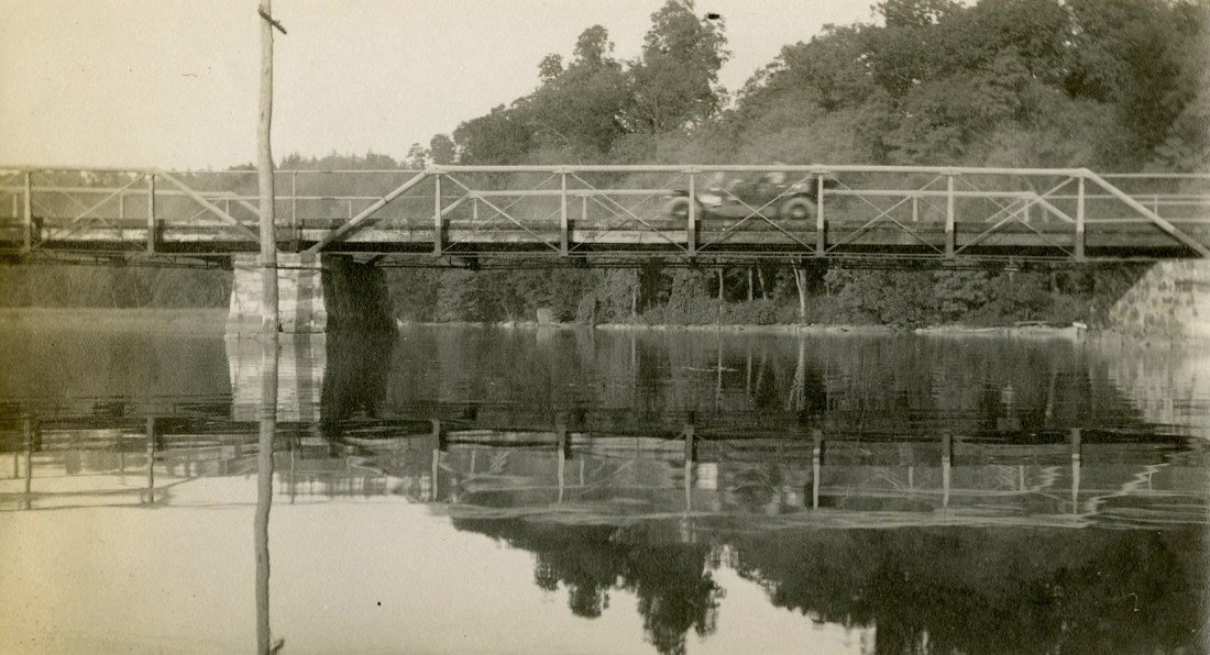
You pass the building, thinking about lunch. Should you stop at the Nikko Inn, in Harmon, or push on to Peekskill? As you zoom across the old bridge you don’t notice the person with a camera down below, who snaps a picture as you pass by. . . .

We’ll never know if this is an accurate description of what was happening when this wonderful photograph was taken, but it’s certainly plausible. Thanks to the Westchester County Historical Society—which has preserved this “decisive moment”2 and graciously allowed us to share it—we get a rare look at what was then known as the Van Cortlandt Bridge, at the dawn of the age of the automobile.
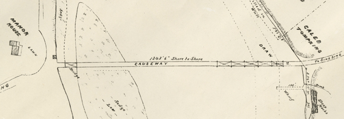
Let’s retrace the route this driver would have taken and see what the area was like in 1912, long before Route 9A and the bland “Crossining” bridge were built. Here’s a map of the area, published just a few years earlier.
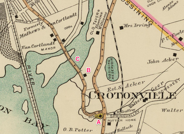
Courtesy of the David Rumsey Map Collection.
A. Crotonville School
Below are two details from the Photo-auto maps book showing the intersection where the Crotonville School was located. The first shows the intersection going north, the second—with the side of the brick school building clearly visible—is the same intersection from the route going south.3

today, the road in the middle goes under Route 9A to Crotonville.

(today the Parker-Bale American Legion Post No. 1597) on the right.
Next is a photo of the front of the school building. If it looks familiar that’s because today the old Crotonville School is the Parker-Bale American Legion Post No. 1597 at 11 Old Albany Post Road. The road that once went down to the Croton River was was cut-off when Route 9A was constructed, but if you drive by to look at Parker-Bale (and you should) you will see a small strip of the old road surface to the right of the building.

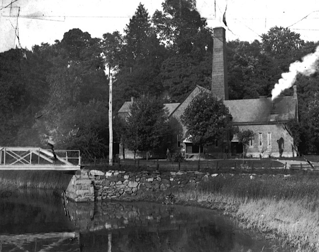
B. Croton Bay Pumping Station
The brick building on the Ossining side of the bridge was the Croton Bay Pumping Station. It was built in 1890 and originally housed two large hydraulic engines that took water from the Indian Brook Reservoir in Crotonville (shown east of the letter “B” on 1908 the map, above) and pumped it to a storage reservoir in the village of Ossining. Today the building is owned by Anthony L. Fiorito Inc., which specializes in water, sewer and drainage services.
C. Van Cortlandt Bridge
The Van Cortlandt bridge across the “mouth of the Croton River” was built sometime after April, 1860, as a result of state legislation authorizing “the board of supervisors of the county Westchester . . . to construct a bridge at or near the mouth of Croton river . . . at such point as they may select between the Hudson river railroad bridge and the present bridge commonly known as the “High Bridge.”4

The building on the far side of the Croton River stood at the end of the long causeway,
in front of the Van Cortlandt Manor house.
The bridge they constructed—actually two bridges, connected by a long causeway—shows up in maps in the 1860s, going from the Ossining side of the river to a point just west of Van Cortlandt Manor.5 Like all bridges on the Croton River during the 19th century the Van Cortlandt Bridge (also known as the Long Bridge and the Wagon Bridge) suffered regular damage from storms, ice and spring freshets and it was repeatedly repaired and rebuilt. Until at least 1871 the long bridge on the Ossining side was a drawbridge, to allow boats to sail up the lower Croton River.6
By 1912 the drawbridge had been removed and the simple iron bridge carried early automobiles over the river until 1922 when the state removed the old span and replaced it with an elegant Beaux-Art reinforced concrete structure. What happened to that bridge? That sad story will be the subject of a future post.
- Photo-auto maps.(New York to Albany and Saratoga Springs, Saratoga Springs to Albany and New York) . . . Compiled by Gardner S. Chapin and Arthur H. Schumacher. Published by the Motor Car Supply Co., Chicago, Ill., 1907. ↩
- See Henri Cartier-Bresson. ↩
- The Photo-auto maps book provided two versions of every route, with photos taken from each direction. ↩
- For the act see Laws of the State of New York Passed at the 83rd Session of the Legislature. Weed, Parsons and Company, 1860. Chap. 268. For photos and information about High Bridge see this previous post. ↩
- See this detail from Lloyd’s topographical map of the Hudson River . . ., published in 1864. ↩
- The railroad bridge had a drawbridge section until 1899. ↩

I grew up in the old house next to the Pumping Station in the 40s and early 50s. The house was owned by Moses Myers from Ossining. My grandparents, Bert and Maude Tompkins, lived there for many years before the both passed in 1950. My Mom and Dad (Lucille Radcliffe and Reed P. Tompkins) moved our family to that house right after my Dad returned from the Navy in 1946.